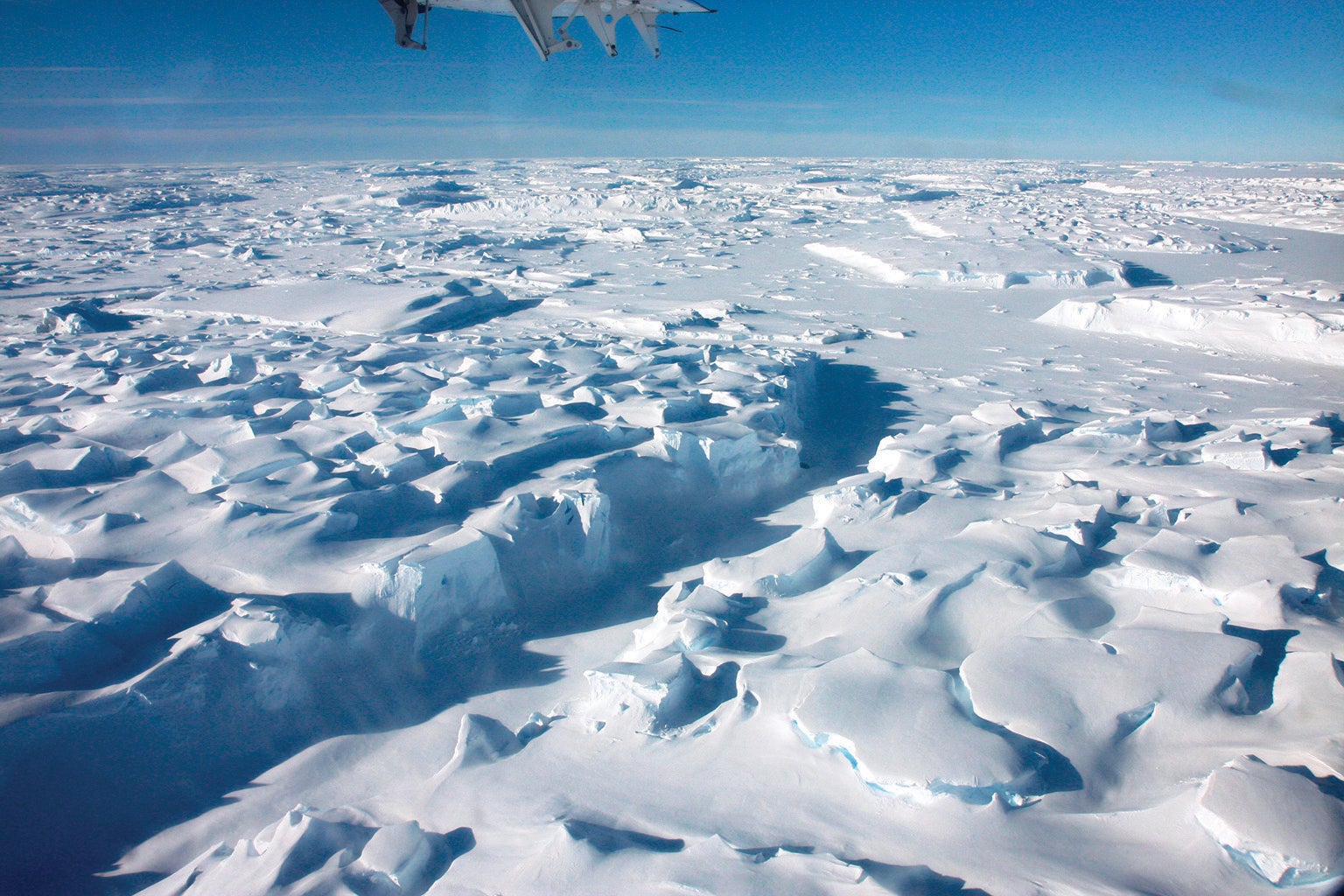
On December 26, 2019, Erin Pettit trudged across a plain of glaring snow and ice, dragging an ice-penetrating radar unit the size of a large suitcase on a red plastic sled behind her. The brittle snow crunched like cornflakes underneath her boots—evidence that it had recently melted and refrozen following a series of warm summer days. Pettit was surveying a part of Antarctica where, until several days before, no other human had ever stepped. A row of red and green nylon flags, flapping in the wind on bamboo poles, extended into the distance, marking a safe route free of hidden, deadly crevasses. The Thwaites Ice Shelf appeared healthy on the surface. But if that were the case, Pettit wouldn't have been there.
Pettit was studying defects within the ice, akin to hidden cracks in an enormous dam, that will determine when the ice shelf might crumble. When it does, the rest of the West Antarctic Ice Sheet behind it could flow right into the ocean, pushing up sea levels around the planet, flooding coastal cities worldwide.
From a distance, the ice shelf looks flat, but as Pettit walked she saw the guide flags ahead of her rise and fall against the horizon—a sign that she was walking across an undulating surface. To Pettit, a glaciologist at Oregon State University in Corvallis, this was significant. It meant that the ice's underside was a rolling landscape—not what anyone expected. In satellite images, the center of the ice shelf looks stable. But it isn't, Pettit says: "There are five or six different ways this thing could fall apart."
On supporting science journalism
If you're enjoying this article, consider supporting our award-winning journalism by subscribing. By purchasing a subscription you are helping to ensure the future of impactful stories about the discoveries and ideas shaping our world today.
The Thwaites Ice Shelf begins where the massive Thwaites Glacier meets the West Antarctic coast. The shelf is a floating slab of ice, several hundred meters thick, extending roughly 50 kilometers into the Southern Ocean, covering between 800 and 1,000 square kilometers. For the past two decades, as the planet has warmed, scientists using satellites and aerial surveys have been watching the Thwaites Ice Shelf deteriorate. The decline has caused widespread alarm because experts have long viewed the Thwaites Glacier as the most vulnerable part of the larger West Antarctic Ice Sheet. The ice shelf acts as a dam, slowing its parent glacier's flow into the ocean. If the shelf were to fall apart, the glacier's slide into the sea would greatly accelerate. The Thwaites Glacier itself holds enough ice to raise the global sea level by 65 centimeters (about two feet). The loss of the Thwaites Glacier would in turn destabilize much of the rest of the West Antarctic Ice Sheet, with enough ice to raise sea levels by 3.2 meters—more than 10 feet.
.png?w=1350)
Credit: Mapping Specialists
Even the most optimistic greenhouse gas emissions scenarios indicate that by 2050 humanity will probably be locked in to at least two meters of sea-level rise in the coming centuries. That will put the homes of at least 10 million people in the U.S. below the high tide line. If the Thwaites Glacier collapses and destabilizes the heart of West Antarctica, then sea-level rise jumps to five meters, placing the homes of at least 20 million U.S. people and another 50 million to 100 million people across the planet below high tide. Although Sacramento, Calif., is not the first city that comes to mind when imagining sea-level rise, it would lose 50 percent of its homes as ocean water pushed 80 kilometers inland through low-lying river deltas. The fate of thousands of coastal towns worldwide hangs on events unfolding in Antarctica right now.
Since 1992 the glacier has hemorrhaged a trillion tons of ice. It is currently losing an additional 75 billion tons of ice every year, and the rate is increasing. What happens next, however, depends on processes that can't be studied from the air—flaws within the shelf that could break it apart, accelerating the glacier's demise. That's why, in 2018, the British National Environmental Research Council and the U.S. National Science Foundation launched a $50-million effort called the International Thwaites Glacier Collaboration to study the glacier and its ice shelf up close.
The collaboration involved eight research teams, including one that reported in September 2022 that the glacier was retreating faster than had been predicted just a few years ago. Two of the teams visited the Thwaites Eastern Ice Shelf between November 2019 and January 2020. Pettit's team examined the central part of the shelf, looking at structural defects and ocean currents underneath. I accompanied her team as an embedded journalist, earning my keep with unskilled labor, much of it involving a snow shovel. Another team investigated the back edge of the ice shelf along the continent's submerged shore, sending a remotely operated submarine down a narrow hole to explore a crucial environment hidden under 600 meters of ice, where the shelf is melting most quickly. The results paint a worrisome picture. The ice shelf "is potentially going to go a lot faster than we expected," Pettit says.
Antarctica's ice sheet has consistently surprised those who study it. In February 1958 researchers in West Antarctica, 700 kilometers inland from the coastline, drilled four meters into the snow, lowered in 450 grams of explosives and detonated it with a muffled fuff that sprayed snow in the air. Geophones sitting facedown on the ice recorded the sound waves that reflected off the hard ground far below. By measuring the return time, Charles Bentley, then a graduate student at Columbia University, made a shocking discovery: the ice in this location was more than 4,000 meters thick—several times thicker than anyone expected—and rested on an old ocean floor 2,500 meters below sea level.
By the 1970s researchers were flying ice-penetrating radar in airplanes that crisscrossed the region. The scattered surveys confirmed that the West Antarctic Ice Sheet sits in a broad basin, deepest toward the center, with large glaciers spilling into the sea through gaps in the basin's outer rim. Even as scientists testified to Congress in the late 1970s about carbon dioxide and the dangers of global warming, most of them didn't think that Antarctica would lose its ice anytime soon. But in 1978 John Mercer, a glaciologist at the Ohio State University, sounded the alarm that West Antarctica represented "a threat of disaster." If the ice sheet lost the shelves separating it from the sea, it might crumble far more quickly than people imagined. Three years later Terry Hughes, a glaciologist at the University of Maine, called out two specific coastal glaciers—Thwaites and Pine Island—as "the weak underbelly" where the collapse of the ice sheet would most likely begin. A pair of papers published in 1998 and 2001 by Eric Rignot, a glaciologist at NASA’s Jet Propulsion Laboratory, showed that these two glaciers were indeed thinning, melting from underneath, allowing ocean water to intrude farther inland under the ice.
Additional aerial surveys since then have shown that the Thwaites Glacier is especially troubling. The ground under the glacier is a relentless slope that drops deeper as it moves inland from the outer, seaward edge, allowing warm ocean water to slide under the glacier, melting it from below. As the ice thins, losing weight, it is also expected to lift off the bed and float on the intruding warm, dense water, allowing the water to penetrate even farther—eventually reaching the 2,500-meter trench at the heart of the continent. If that happens, "you're going to unload the West Antarctic Ice Sheet," says Ted Scambos, a glaciologist at the University of Colorado Boulder, who traveled with Pettit's team in 2019–2020.
The glacier flows into the sea in two arms that move at different speeds. The fast arm on its western side is a fragile, floating "ice tongue." In satellite images, it resembles a shattered windshield, composed of hundreds of icebergs a kilometer or two across drifting into the ocean. The "slow arm," on the glacier's eastern side, is a smaller ice shelf that for years seemed more stable. The front edge butts into a submarine mountain ridge 40 kilometers off the coast. This ridge acts like a doorstop, creating back pressure that holds the ice shelf together.
Pettit and her team chose the mountain-buttressed eastern shelf for their expedition. In satellite images, the shelf's central region appeared relatively stable, its surface smooth enough for small ski-mounted planes to land. A pair of mountaineers could scout for hidden crevasses and establish safe routes, allowing the team to move around freely. Pettit worried that visiting an apparently undamaged part of the ice shelf might limit their opportunity to learn something new. She didn't need to worry.
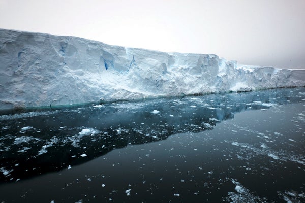
The western ice tongue of Thwaites has splintered into hundreds of icebergs, which look like raised plateaus, interspersed with sea ice perhaps a meter thick, all covered in snow. Credit: Douglas Fox
Antarctic fieldwork requires sending tons of fuel, food and survival gear ahead of time. The field team has to be supported by layers of transport, workers and staging camps. All told, the Thwaites research expeditions required several hundred thousand kilograms of equipment and supplies delivered by ships, planes and convoys of tractors towing sleds across hundreds of kilometers of ice that had been searched ahead of time for crevasses. The British Antarctic Survey and the U.S. Antarctic Program staged some of that gear a year or two in advance. But in Antarctica, even this kind of preparation isn't enough to avoid complications.
In September 2019, two months before I joined Pettit's team as they departed for the frozen continent, they received new satellite images showing two new rifts in the ice shelf. These "daggers" originated where the ice collides with the undersea mountain; the rifts had surged inward toward the coast, to within five kilometers of our planned destination. Expedition leaders worried that one of these rifts could rip through the camp, but the team decided to press forward, with a colleague back home tracking the rifts via satellite. After a series of storms delayed the expedition by a few weeks, we reached the Thwaites Eastern Ice Shelf in mid-December 2019. We assembled a row of tents, protected from the constant easterly winds by walls of snow blocks shoveled and handsawed from the landscape, and set up gear for what would be a month of arduous work to come.
The first couple of days were relatively warm. Our boots plunged deeply into the slushy snow, and puddles of meltwater pooled up along the tents. A series of giant ice cliffs, eight kilometers away, were visible to the south. Those upheavals marked the zone where the ice cracked and flexed as it transitioned from a grounded glacier into a floating ice shelf.
As the weather cooled and the snow hardened, Pettit made her first long walk, dragging her radar along preplanned lines. The radar provided two-dimensional profiles of the ice shelf's internal layers, like the slices of a hospital MRI scan. Those first glimpses proved far more interesting than Pettit expected.
Her radar showed that layers in the top 25 meters of the shelf were smooth and mostly flat, but below that they suddenly turned jagged. Pettit speculated that the jagged layers had been part of the ice when it juddered across the rocky coastline bed and started to float seaward, perhaps 15 years before; they were forever imprinted with the trauma of that transition. The smooth layers represented snow that had fallen on top since then, when the ice was afloat.
More surprising, Pettit found that the shelf's underside—a place that human eyes had never seen—looked strangely ordered, as if it had somehow been sculpted intentionally. The underside was corrugated with a series of trenches that ran perpendicular to the direction of ice flow, like waves offshore from a beach. Each trench was 500 to 700 meters wide and cut as far as 50 meters up into the ice, the height of a 12-story building. "These things are huge," Pettit told me. Oddest of all, the trench walls weren't smooth, as one might expect of melting ice. They were stair-stepped terraces, with a series of vertical walls each five to eight meters tall, like the sides of an open-pit mine. "We don't know what these stepped things are," she said.
These stair-stepped trenches had escaped detection in previous surveys. Airborne radar measurements are taken from planes moving at least 150 kilometers per hour, so each reading is an average over a long swath of ice. Pettit dragged her radar at a stately three kilometers per hour, allowing her to capture a much finer-grained picture.
As Pettit was getting her first look at the strange terraced structures, her colleagues were starting to see hints of another unexpected observation: the bottom of the ice was not melting the way they expected. On January 2, 2020, I wolfed down a breakfast of dehydrated porridge with Christian Wild, a postdoctoral scholar who works with Pettit. He and I then drove a snowmobile out into a frigid snowfall. The sound of the engine was muffled, and the wan light seemed to seep in from all directions, leaving no shadows, no texture and no hint of the approaching bumps that we trundled over. We steered along our GPS line, with just enough visibility to see each new flag appear silently into view, then dissolve behind us in a gentle slurry of snowflakes.
At a series of stops, Wild used high-precision radar to measure the thickness of the ice shelf, accurate to a few millimeters. He had already measured the same points a week earlier. Because satellite estimates suggested the ice shelf was thinning an average of two or three meters per year, he expected to find the ice three to six centimeters thinner than the week before. To his astonishment, he saw almost no thinning. "It doesn't make any sense," he said toward the end of a long day.
Back at camp, other team members prepared to measure the temperature of the ocean currents flowing under the ice shelf. Over several days they tossed 6,000 kilograms of hard snow, one block at a time, into a canvas-sided tank the size of a large hot tub. They melted the snow and heated the water, then used it to make a hole as wide as a dinner plate 250 meters down through the shelf. Scambos lowered a string of sensors through this hole into the ocean water below. For the next year or two this sensor station, powered in part by solar panels on a small steel tower, would measure the water temperature, salinity and currents.
Initial readings showed that warm, dense water was indeed flowing under the shelf. At two degrees above freezing, it should be "enough to melt many meters of ice over the course of a year," Scambos said. But the ice wasn't feeling the heat. A layer of cold water sat up against the shelf's underside. Because that water came from the melting of glacial ice (which itself comes from snow), it contained little salt, so it was buoyant, hugging the bottom of the shelf and shielding it from the warmer, saltier water below.
By the end of the expedition Pettit's team had encountered a series of revelations that defied previous views of the ice shelf. First, its underside was eroded with deep trenches, and the slopes of those trenches were organized into stair-stepped terraces. Second, the ice didn't appear to be thinning at the points Wild measured, which disagreed with satellite surveys. Finally, the underside of the shelf didn't seem to be affected by heat from the deep ocean, because it was insulated by a layer of cold, buoyant water. This set of findings was difficult to explain, but another research expedition, operating not far away, would help make sense of the surprises.
Eight kilometers southeast of Pettit's camp, the other group of scientists was getting a first look at the ice shelf's grounding line—the long contour of ground where ice lifts off the land and floats on the sea. In this hidden place, scientists believed the underside of the ice was melting most quickly.
On January 11, 2020, researchers at the camp lowered a black-and-yellow cylindrical vehicle, as wide as two hands and 3.5 meters long, by cable into a narrow hole in the ice. Engineers led by Britney Schmidt, a planetary and polar scientist now at Cornell University (then at the Georgia Institute of Technology), had spent eight years developing this remotely operated vehicle, called Icefin. They had driven it under sea ice more than a meter thick and under the edges of two small ice shelves, where it could be winched out by cable if it got stuck. But they had never lowered this precious object through such a massive slab.


Erin Pettit pulls an ice-penetrating radar (top) that can peer down into the ice shelf. She walked for many kilometers beyond base camp, where tents were protected from constant wind by walls made of handsawed snow blocks (bottom). Credit: Douglas Fox
Schmidt sees Icefin as a prototype of a probe that will one day explore vast bodies of water in the outer solar system, hidden underneath 10 or 20 kilometers of ice on Jupiter's and Saturn's moons. In Antarctica, Icefin would measure the ocean temperatures, currents and rates of melting under the ice. Perhaps more important, its video cameras and sonar would allow the researchers to visually explore this remote environment. Schmidt wasn't looking to validate any of Pettit's observations per se, but the two researchers were working relatively close by, on the same ice shelf, so serendipity could play a role.
After descending through the 600 meters of ice, the vehicle emerged into a layer of ocean water only 50 meters deep. Schmidt, sitting in a nearby tent, steered Icefin with her thumbs on the controller of a PlayStation 4 console. The glassy ceiling of the ice's underside scrolled past on her video monitor as Icefin glided along, sending video up its fiber-optic tether. For eight hours Schmidt guided the vehicle as far as two kilometers from the borehole, into narrow spaces where less than a meter of water separated the ice above from the gravelly, gray-brown seafloor below. This was newly exposed seafloor; the thinning ice had pulled away from it only a few days or weeks before. An occasional fish or shrimp drifted by.
In most places, the currents were sluggish, and close to the ice the water was stratified. As the vehicle approached the grounding line, the water near the ice was at most one degree Celsius above freezing, even though warmer water lay only a few meters away. Icefin's measurements suggested that the underside of the ice was melting at a modest rate of about two meters a year. In some places, meltwater had refrozen onto the bottom of the glacier, revealing a distinct layer of crystal-clear ice, several centimeters thick. Satellite observations had shown this region rapidly thinning, so the findings were at odds with the team's expectations, says Keith Nicholls, an oceanographer at the British Antarctic Survey, who co-led the research at the camp. The overall lack of melting was puzzling, he said: "Extraordinary, really."
As Icefin swam around, it occasionally encountered a clue that would help explain not only these unanticipated observations but also what Pettit's team had found. Cruising slowly along the shelf's fairly flat underside, Icefin came across a vertical wall cut up into the ice—a stair-stepped terrace like Pettit had seen in her radar traces. And the ice on the terrace walls seemed to be melting far more quickly than the surrounding horizontal underside. In the video, there were blurry ripples in the water, where Icefin's spotlight refracted through gushing eddies of saltwater and freshwater swirling together. Icefin also frequently found dark cracks gaping in the ice—basal crevasses as wide as 100 meters. Schmidt steered Icefin up into several of the crevasses, and there again, she found the water swirling and blurry, suggesting the ice may have been melting quickly.
At the December 2021 American Geophysical Union (AGU) meeting in New Orleans, Schmidt's team presented a careful analysis of Icefin's data, confirming that the vertical ice surfaces are playing a pivotal role in the demise of the Thwaites Ice Shelf. Peter Washam, a research scientist at Cornell, reported that the terrace walls were melting five times more quickly than horizontal ice surfaces, losing 10 or more meters of ice a year. The crevasse walls were melting even more quickly—up to 10 times as fast, losing 20 meters of ice a year. Washam noted that the water currents became turbulent as they encountered these steep surfaces, and this brought water into contact with the ice in ways that more efficiently melted it.
The vertical steps may originate from subtle ups and downs present on the ice's underside when it first pulls up from the bed along the grounding line. The ice might fracture and melt more quickly in these uneven spots, steepening the slope—which increases the melt rate, causing the slope to steepen even more, until it forms a terrace wall that is nearly vertical. As ice melts from these vertical surfaces, the terrace walls migrate horizontally, Scambos says. A basal crevasse that is 10 meters across might widen to 30 or even 50 meters within a year. The melting of the Thwaites Ice Shelf's underside isn't a uniform process; it is highly localized, directed by the topography interacting with currents.
If most of the melt is happening on the vertical ice faces, that could help explain why Wild saw no signs of thinning in many of the places he measured. After returning home in 2020, Pettit plotted Wild's points on her radar survey lines showing the terrace walls. In each case, Wild's measurements fell some distance from the closest wall, in a spot where the ice base was horizontal and so maybe not melting much. This isn't unusual, Pettit says, because the walls are spaced far enough apart that Wild was unlikely to hit one by chance. The instrument station that Scambos left behind also seems to be located some distance from the nearest wall; it, too, has shown very little ice thinning.
If the vertical walls are melting quickly, they should also be migrating horizontally across the ice base, Pettit says. At some point, one of those vertical faces will sweep past Scambos's instrument station, "and we will see a huge amount of melt in a short time," she says—perhaps eight meters in a week. "If we see that, it would be supercool."
Schmidt's observations may also explain another feature of the terraced trenches Pettit saw near camp. After Pettit returned home, she examined her radar traces and noticed something peculiar: in the highest segment of a trench, she often saw a stack of inverted U-shaped radar reflections—the classic signature of a crevasse penetrating up into the ceiling. This might occur because the thinner ice over a trench sags like a flimsy bridge; as the ice flexes downward, its bulging belly cracks open. This newly formed basal crevasse may pull in warmer water from below. That would cause the walls of the crevasse to melt and migrate outward, widening until its ceiling is broad enough that it also sags and cracks open—a repeating cycle that could drive cracks ever farther into the ice above.
The massive terraced trenches may have started out as individual basal crevasses, like the ones Schmidt saw eight kilometers upstream at the grounding zone. When Elisabeth Clyne, then a graduate student at Pennsylvania State University, examined radar traces from around the grounding zone, she saw signs that as crevasses moved farther out toward the sea, at roughly 600 meters a year, they were already starting to grow wider and taller through cycles of melting, sagging and cracking. She reported her analysis at the 2021 AGU meeting in New Orleans. Pettit suspects that these trenches may eventually penetrate all the way up through the shelf or at least cut far enough up through the ice that the shelf becomes prone to breaking from other stresses. This process could splinter the shelf into an unsteady mass of giant, shifting shards that will no longer stabilize one of Antarctica's largest glaciers.

Credit: Violet Isabelle Frances for Bryan Christie Design
Although Thwaites's western ice tongue lost 80 percent of its area between 1997 and 2022, the eastern shelf shrank only about 15 percent. Its seaward snout remains pressed against the undersea mountain ridge, which crests roughly 400 meters underneath the ocean's surface. The pressure from this "pinning point" holds the ice together, but the status quo may not last much longer.
In February 2022 Wild published an analysis of satellite measurements showing that the front face of the ice in contact with the underwater mountain ridge is thinning by 30 centimeters a year. At that rate, it will lift off the top of the mountains in less than 10 years. Wild expects that when this happens, the eastern ice shelf will rapidly "disaggregate" into a flotilla of icebergs. But it may meet its end even sooner. If focused terrace melting is driving cracks upward through the ice, that could amplify the mechanical stresses that are already tearing at the shelf.
Massive splintering is already happening just upstream of the mountain ridge. Over the past decade the ice there has fragmented into a logjam of long shards held together only by pressure and friction. A series of satellite images, stitched into an animation by Andrew Fleming of the British Antarctic Survey, shows that these shards are sliding past one another with increasing ease. As a result, the splintering shelf is starting to deform and flow around the mountain ridge more quickly and in new directions, like a river that parts as it flows around a boulder. The mountain—once a stabilizing buttress—is now acting as a wedge, sending several "dagger" rifts surging back toward land. These are the same rifts that we saw via satellite just before we left for Antarctica in 2019.
"The thing is falling apart," says Karen Alley, a glaciologist at the University of Manitoba in Winnipeg, who published an analysis of these ice-flow patterns in November 2021. Even if the ice disconnects from the mountain ridge more slowly than expected, another scenario could doom the shelf. Those dagger rifts could keep lengthening until they intersect with the rising trenches advancing seaward from shore. This intersection of structural defects could lead to a shattering of the entire shelf.
In every scenario, the eastern ice shelf will meet a fate similar to the western ice tongue: its constituent shards will disconnect and drift away. Once that happens the eastern trunk of the Thwaites Glacier will break away from its pinning point, and the western trunk could also speed up. "This whole thing is going to go much faster once the ice [shelf] is all cleared out," Scambos predicts.


Christian Wild prepares a high-precision radar (top) to measure ice-shelf thickness to within a few millimeters. Martin Truffer sets up an instrument station (bottom) that would record the shelf's advancement and upheaval for two years after researchers left Thwaites. Credit: Douglas Fox
Pettit’s team left Thwaites in late January 2020, but they continued to monitor the shelf's health with solar-powered instruments they lowered into the ocean through holes drilled through the ice. In January 2022 Scambos and Wild returned to our camp site for a few chaotic days to retrieve the data. Antennae and solar towers that once rose seven meters above the ice were mostly buried in hard, icy snow. Scambos, Wild and two other workers used ice-penetrating radar to find the covered instruments. They then chainsawed narrow pits six meters down into the ice to retrieve the treasured data cards.
In hopes of getting another year of data out of his instruments, Scambos reinforced the steel towers that had been bent like paper clips and reset the modems that had been fried by static discharge during windstorms. Sensors on the towers had detected winds up to 250 kilometers per hour—nearly Category 5 hurricane speeds and twice what Scambos expected.
GPS units from those stations show that in the two and a half years after they were installed, the ice shelf's seaward movement increased from 620 meters a year to 980 meters a year. As Scambos and Wild gazed down from their Twin Otter plane in January 2022, they spotted several new tears in the shelf—three kilometers long and several hundred meters wide—where it lifts off the seafloor. Ragged cliffs of ice tilted 50 meters up into the air, exposing deep layers that had not seen daylight for thousands of years. "I think it's losing contact with everything that used to be bracing it," Scambos says. The ice shelf is not just separating from its pinning point. As it speeds up, it is also stretching and tearing away from the glacier upstream.
The team was so alarmed that Pettit and Wild decided they would return in December 2022 to install a new instrument station: "BOB," short for Breakup Observer. They hope BOB will survive long enough to record the final throes of the ice shelf as it fractures into shards. It might not take long.
Scambos speculated that as Pettit and Wild camped on the ice shelf, they might wake up one morning to find themselves on a free-floating iceberg. "As long as they're not near one of the rifts, they're not even going to know at first," he said. Any sounds or vibrations from a crevasse breaching the surface from below might be muffled. Subtle clues would gradually alert them. As the iceberg slowly rotated, their handheld GPS would seem to guide them in the wrong direction, and the sun might also move the wrong way. "You're on this giant white lily pad," Scambos said, "and your only reference is that you're used to having the sun in a certain place at a certain time of day."